12371 and 12407 Lima Road, Fort Wayne, Indiana: The Irene Byron Sanatorium and TB Hospital

Well, it only took me 5 months, but I promised I’d return and I did! After scouting out most of what remains of the Irene Byron Sanatorium site back in July, I was finally able to return to this location to photograph the only remaining building from the original sanatorium/hospital complex! (If you missed the original post, find it here).

On a 28-degree day (Fahrenheit, that is), I ventured for a walk around the fenced-off building that sits to the far west of the property, secluded in derilection until its demolition day arrives. But until then, a walk through time. Join me?

Looking roughly southwest from a small, paved area, we see the final building that remains on the sanatorium property. I wish I could tell you more about what this building was, where the other sanatorium buildings once stood, and lay out the property in organized map-form, but I’m still in the process of determining what and where everything was. For now, you’ll just have to wander with me, and wonder…
The southern end of the building, looking west.
With the building to my back, this shot looks straight east. Note the fragmented sidewalks, now leading nowhere, that still loop about the property.
Looking east/northeast, another look at the sidewalks that creep about the dead grass.
The southern end/facade.
Still looking at the southern facade, now with the back (west) facade of the building coming into view. This shot looks almost dead north.
The back (west) facade. Photo taken looking east.
Looking southeast, this shows the north and west facades of the building.
North facade, looking south.
Due north of the building, there is a copse of old pine trees with something curious between them…
An old sidewalk and foundation sit discreetly below the towering canopies.
Looking northeast, a sidewalk still runs away from the old building site and takes a sharp right to the east.
Looking west, a view of the foundation amongst the trees from the other direction.
A final look at the mysterious building.

With the building as thoroughly photographed as possible, I venture east toward Lima Road for a look at the final standing structure on Sanatorium property — a tiny building that previously sheltered visitors awaiting the arrival of the Interurban train, which ran from Fort Wayne north to Huntertown and beyond.

Looking west as a sidewalk leads from the building we just visited toward Lima Road.
Looking south at the remnants of the Byron Health Center/Allen County Infirmary complex.
Due east: the old Interurban shelter and Lima Road in the background.
North facade/entrance.
Looking east at Lima Road through the window.
Old electrical box on the east wall inside the shelter.
Looking out the south window.
Looking out the west window, with the building we just came from visible in the distance.
Looking out the door on the north wall, facing roughly northeast.
View facing west/southwest.

Thus concludes another borderline-legal, short-lived walk through a place that will soon live only in memory. Thanks for strolling with me and farewell til our next adventure.

Byron Health Center and the Old Allen County Infirmary, 12101 Lima Road, Fort Wayne, Indiana

That’ll teach me to ask stupid questions.

In my last post, I asked — tongue in cheek, I might add! — about what they’d knock down next. I should have known better.

The (not-so-simple) History

Meet the Byron Health Center, located at the corner of Lima and Carroll Roads in Fort Wayne, Indiana. In 1916, this property (well, technically the property just north of where the Byron Health Center stands today) started its human-occupied life as a tent hospital called Fort Recovery that was built largely due to the efforts of Irene Byron, a local nurse and the executive secretary of the Fort Wayne Anti-Tuberculosis League. Soon, a permanent TB hospital was built — the Irene Byron Hospital, which gave homage to the nurse who poured her life into its founding. The Allen County Poor Farm, which became known as the Allen County Home, also moved here in 1916. Also on this site at some point over the years was a nursing school, physician homes associated with the TB hospital, and a penal farm. Let’s put it this way: the history here is long and expansive, and untangling it all from itself has proven a lot more complicated than I thought when I started out on this venture!

With that said, please note that the research burden on this article and those to follow will be significant. These posts will be subject to high amounts of editing as I garner new information and clarify old details! Please be patient as I try to make this as accurate and factual as possible. [/end admin PSA]

Back to the interesting stuff! Since its founding, this site was occupied and used in some manner all the way up until May 2020, when the building of Byron Health Center’s new facility downtown was complete, and the entirety of the staff and patients relocated, leaving the shell of a sprawling facility and acreage, rich in history, just begging to be demolished.

Not surprisingly, the county soon decided to oblige. Nine days ago, plans to demolish the site and sell the land were announced. Over the past several months, efforts to clear the buildings and take care of asbestos has left the facility with gaping holes in her walls, a sad remnant of the pride she once was.

Naturally, I couldn’t resist. Join me for one final tour, will you?

But First, The Maps…

If there’s one thing I can’t stand, it’s not knowing exactly where I am or what I’m looking at, so for the sake of clarity, I made you some aerial maps to help you understand what you’re seeing on the ground and where it’s located. The property is far too large to be contained in one photo, so I will post the northern-most photo first, followed by the property immediately south, etc. There is some overlap between photos, so it should be fairly easy (let me know if it isn’t!) to follow along.

FORT RECOVERY / IRENE BYRON SANATARIUM / IRENE BYRON TUBERCULOSIS HOSPITAL: The property above housed the original Fort Recovery as well as the Irene Byron Sanatarium and TB hospital, both to the north and south of Recovery Road. The red area shows the route I took through this area of the property. Please note the building standing at the western edge, which I wasn’t able to photograph due to a dying phone and fading sunlight. Also note the number of old roads and indentations in the ground remaining from structures that are no longer present.
KIDDER HOUSE / DRAPER – SHERWOOD HOUSE: This is the old site of the Kidder House and Draper-Sherwood House, both physician residences associated with the TB hospital. The small, extremely narrow path marked “D” leads north to the old Fort Recovery/Sanatarium site. The red, once again, shows my path through this property.
BYRON HEALTH CENTER / ALLEN COUNTY HOME / ALLEN COUNTY HEALTH CENTER. This is the Byron Health Center complex. According to an old map, the original buildings of the Allen County Home (aka the Allen County Poor Farm) sit just behind the newer Byron Health Center buildings, the latter of which are located to the far east of the property, closest to Lima Rd/Rte 3. Numbers marked on this map show entrance numbers as they appeared on the buildings. Site A will be mentioned in a later photograph.

A Word to the Wise:

This is private property and is clearly marked just about everywhere with prominent, bordering-on-redundant NO TRESPASSING signs. At no point did I enter the premises; I only photographed what I could from the exterior of the buildings. If you’re interested in photos of the inside, check out this blogger, who snagged some photos of the interior during an auction tour (scroll to the last post for pics!)
Inside Byron Health Center

And finally, the really interesting part…

On the approach: entering the property from the south (off Carroll Road) heading north into the main parking lot.
This photo shows the far south end of the complex. On the back of this building are entrances 6 and 7. This is the front of the same building, which faces east. Note the awnings for reference and then proceed below…
Now looking straight west at the same portion of building as the photo above, this is a frontal view of the eastern side of the southern-most building.
Looking directly at the Byron Health Center from the south. The large, windowed building to the right faces Lima Road / Rte 3. Directly ahead are the roundabout and entrances 2 and 3.
Looking slightly more northwest than the image above. This shows the long, hallway-like structure that connects the main building complex to the southern-most structure on the property.
There are two entrances off Lima Road to this facility, and this is the southern one. It still has its sign intact, which is perhaps the only one remaining on this site.
Southern side of the front facade (facing east/Lima Rd) of Byron Health Center. (Photograph taken facing northwest)
Byron Health Center in all her remaining glory.
Heading under the awning of the front entrance to Byron Health Center. Note the parking area to the right and the entrance number conveniently displayed on the awning.
The old front entrance to Byron Health Center. The damage to the interior of the building is evident even from outside.
Northern end of Byron Health Center.
Looking southwest at Bryon Health Center, front facade.
This is the north-facing facade of Byron Health Center, entrance 25.
Entrance 23 is visible just to the left of center past the small parking lot. This photo shows the end of the more modern structure (Byron Health Center) and shows the older building connected to it, presumably part of the old Allen County Home.
Looking southwest on the northern-most portion of the old buidling. Site A is visible where the boarded area sits just below the tree branches.
Site A.
Old sign for the Allen County Work Release Program, which, word has it, was housed in this building as recently as 2020.
Looking directly south at entrance 19.
This photo is of the northern-most parking lot, facing northwest. An old, unused basketball hoop waits for demo day.
Looking southeast from the northern lot. Entrances 19 and 18 are visible.
Heading back from whence I came, this is the back (western-facing) facade of the old Byron Health Center with part of the small lot visible on the right.
Looking south at the small lot pictured partially above. The back (west) wall of the old Byron Health Center is on the far left.
Back under the front awning. heading south.
A fleeting close-up of the front door.
We are now at the southern end of the old Byron Health Center, looking at the western facade. The door just right of center is entrance 2.
Looking north, entrance 2 is now out of frame to the right. This is the old roundabout. Entrance 3 is under the awning just to right of center.
Entrance 3 (facing west).
Entrance 3 now to the right; looking west at the older building behind Byron Health Center.
The roundabout from the northern-most point. An old lantern bows its head as if in memory of those residents long forgotten.
This is now the western facade of the southern-most building, entrances 7 and 6.
Western facade of the long, hall-like structure that connects the southern building to the main complex.
Southern facades of the Allen County Home. Entrance 9 visible far right, entrance 10 and 13 visible on the left (two white doors).
Western facade of long hallway. The back (west-facing) side of Bryon Health Center is visible in the background.
Closer view of the southern facade of the old Allen County Home. Entrance 10 (white door) to the far left.
Entrance 10. Photo taken facing northwest.
Entrances 11, 12, 13, still on the southern facade of the Allen County Home.
Southwest corner of the Allen County Home. Entrance 14 is visible just to the right of center.
Entrance 14 and outbuildings at the western edge of the facility.
Sunset over the old buildings. A final outbuilding, separated from the main complex by a street, is visible to the left.
Close-up of the separated outbuilding.
Western facade of the Allen County Home (back side). Entrance 14 to the right of center.
Back (western facade) of Allen County Home.
Northern-most portion of the western (back) side of the Allen County Home. Entrances 15 and 16 visible.
An old road that departs the road encircling the Byron Health Center complex and heads northwest toward still-occupied (but undeniably old) county facilities.
Northern-most portion of the back (west) facade of the Old County Home. Entrance 18 visible.
Looking east down the northern-most road on the Byron Health Center site. North parking lot off to left.
Back along the northern facade of the Old County Home, this is a close-up of Site A (marked on the aerial map above).
Old baseball field, which sits just north of the complex.
Looking north with Lima / Rte 3 on the right and the brick pillars that marked the driveways of the old Kidder & Draper-Sherwood Homes on the left.
Heading onto the driveway of the southern-most pair of pillars.
Heading west down the driveway, which splits to either side and forms a circle.
Site A on the Kidder / Draper-Sherwood Home map. Photograph taken facing roughly southeast. The drive that comes off the cirle and heads southwest appears to dead-end here, but you can see on the aerial map that at one point, it continued.
Looking north from site A at the southern edge of the circular road.
Looking north at site B.
Site B, photographed facing northwest. This appears to be an old, concrete foundation – perhaps of one of the homes that once stood here.
Site B to the left, this shows the road continuing north before it bends right (east).
Standing on site B, this photograph was taken facing east toward Lima. The two driveways, marked by pillars, are visible to the left and right in this photo.
Site C, located behind Site B, appears to be an old covered well with a hand-pump.
Looking east at Site B while standing near site C.
Looking north at the tiny path that runs northwest toward the old Fort Recovery / Irene Bryon Hospital site (marked D on the map).
Site E – a large, paved area where Site D (the narrow walking path) ends, looking roughtly north.
Facing west from roughly Site E, a road runs westward, just to the south of the only remaining building on Fort Recovery / Irene Byron Hospital property.
A distant shot, facing roughly northwest, of the only remaining building on the old Fort Recovery / Sanatarium property, looking toward Site F.
Looking east toward Site G, down the northern-most driveway that leads to Lima Road from the old Fort Recovery / Sanatarium site.
Site G: northern driveway pillars that mark the old entrance to the Fort Recovery / Sanatarium site.
Looking north toward Recovery Road from Site G.
West toward the remaining building from Site G.
Beyond the pillar of Site G sits Site H – a small, abandoned structure that may have once been a train or trolley shelter as Fort Wayne’s section of the T&C interurban would have run down Lima during the early years of this property’s history. For more on the interurban, see KPC News – Interurban Railway
Looking northwest toward the water tower / Recovery Road. One of the old maps I found indicates that at least some part of Fort Recovery / the old Sanatarium lay north of Recovery Road on a site that is now occupied by the Allen County Sheriff’s office and Pro-Build.

Coming Soon!

This property has left me with no shortage of potential research, and next up is a look into the personal history of Irene Byron, the nurse and healthcare pioneer who risked her life to care for Allen County’s TB-stricken patients, and eventually, the servicemen of WWI. A great deal is known about her accomplishments, but who was Irene Byron? Who were her parents? Where was she from? All that and more, coming soon!

SOURCES:

https://www.wane.com/news/local-news/construction-of-new-byron-health-center-underway/

https://www.wane.com/news/local-news/commissioners-former-irene-byron-site-on-lima-road-set-to-be-sold-after-demolition/

https://www.news-sentinel.com/news/local-news/2020/02/21/before-county-sells-byron-property-it-wants-to-know-where-the-graves-are/

15529 Old Lima Road, Huntertown, IN

Oh, Huntertown. What will you knock over next?

After the loss of 2 irreplaceable old farm houses along SR3/Lima Road, I noticed this house has a “CONDEMNED” notice on the front door.

The home is expansive–2 stories with a large, white-picket fenced-in side yard. Trees and overgrowth obscure the view of her aged visage these days, but that doesn’t stop the imagination from wondering who built her, lived in her, loved her, and ultimately left her?

Zillow and other reality sites generally agree that she was built in 1890. She has 6 bedrooms, 3 baths, and boasts an expansive 3,172 square feet of living space.

A look from across the street is hardly a look at all due to overgrowth and vegetation neglect.

Public records show that Conrad Tucker owned the home in the 1960’s with his first wife, Marie, and then into the 90’s with his second wife, Beverly. Gregory R. Williams then owned the home until the early 2000’s, and further records indicate that one Richard Christiansen is the current owner.

As to how and why this old beauty fell into a state of neglect and disrepair, we can only speculate and treasure her numbered days.

Google image, courtesy of the year 2011.
Google image, 2011

15000 Block, Echowood Lane, Fort Wayne, IN 46818

Huntertown, Indiana is an out-of-the-way speck on the map just north of Fort Wayne.  Tiny and almost invisible off Route 3, it is a unique spot, steeped in a history rich in agriculture and medicine–a history that is slowly being knocked down, developed and forgotten.

Recently, one of the larger, more visible historic farmhouses on Route 3 was demolished–the Charles F. Bleke house, built c. 1875 according to some, but certainly in place by 1891 according to the year that used to grace the front of the house just below the peak of the roof.  (Stay tuned for a genealogy/history post on this house!)

It is to my great disappointment that I never made it to the Charles F. Bleke house before it was destroyed.  But a neighboring house to the north just became visible thanks to yet more development in the area.  A rundown old brick farmhouse, similar in style and construction to the C. F. Bleke Farmhouse, sits in the middle of a once-treelined dirt road, exposed to the passing traffic on Route 3 now that the foliage around it has been torn down–certainly a foreshadowing of its fate.  Two other structures–a garage and a newer house–also grace the sides of this isolated farm road.

THE HOUSES

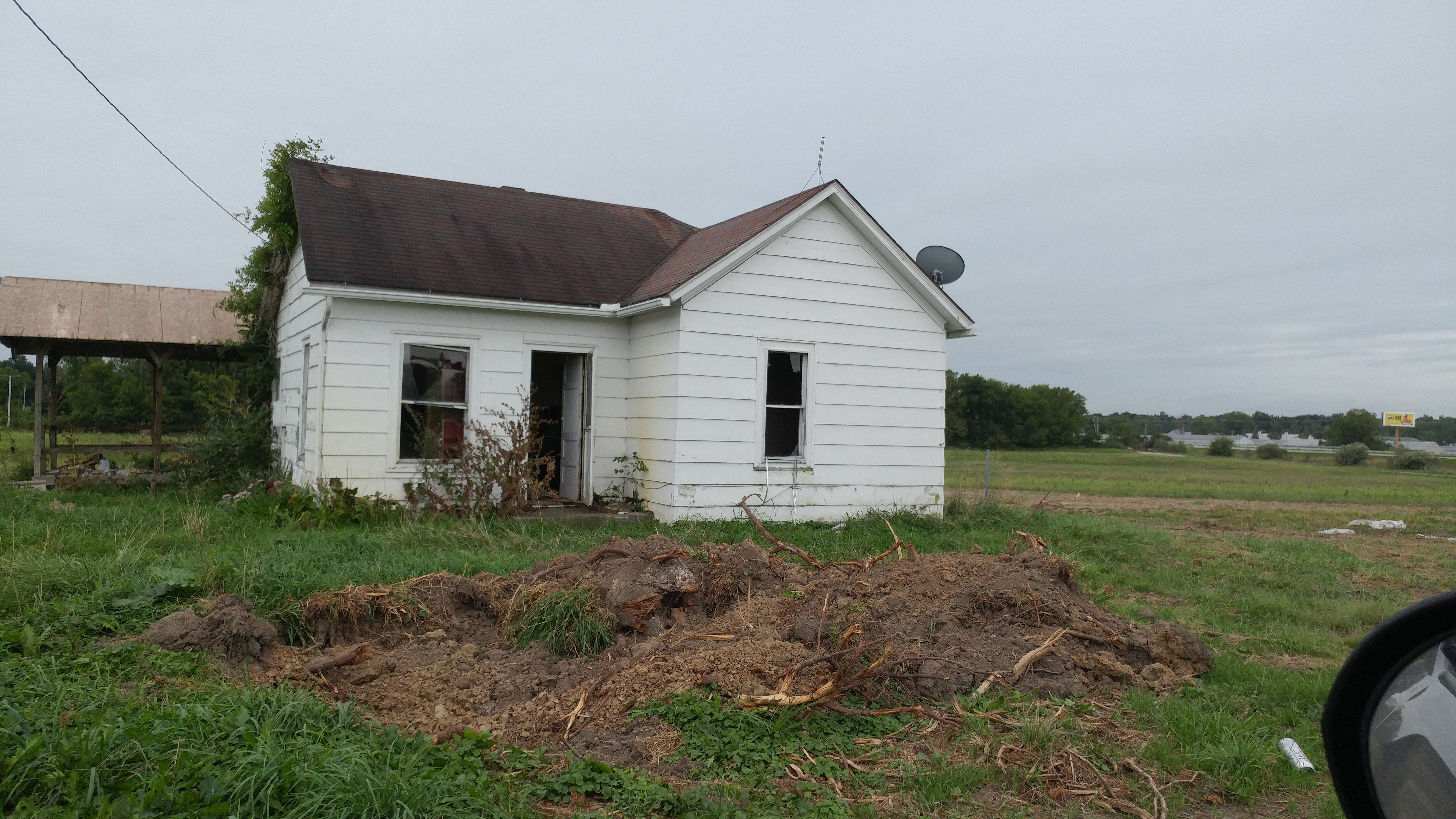
15000 or 14515 Echowood Lane:
A small, 2-bedroom, 1 bath house is the first you’ll come across when you head down Echowood.  The front door stands open, the windows are broken, and it’s clear that no one calls this place home anymore.

0907180855
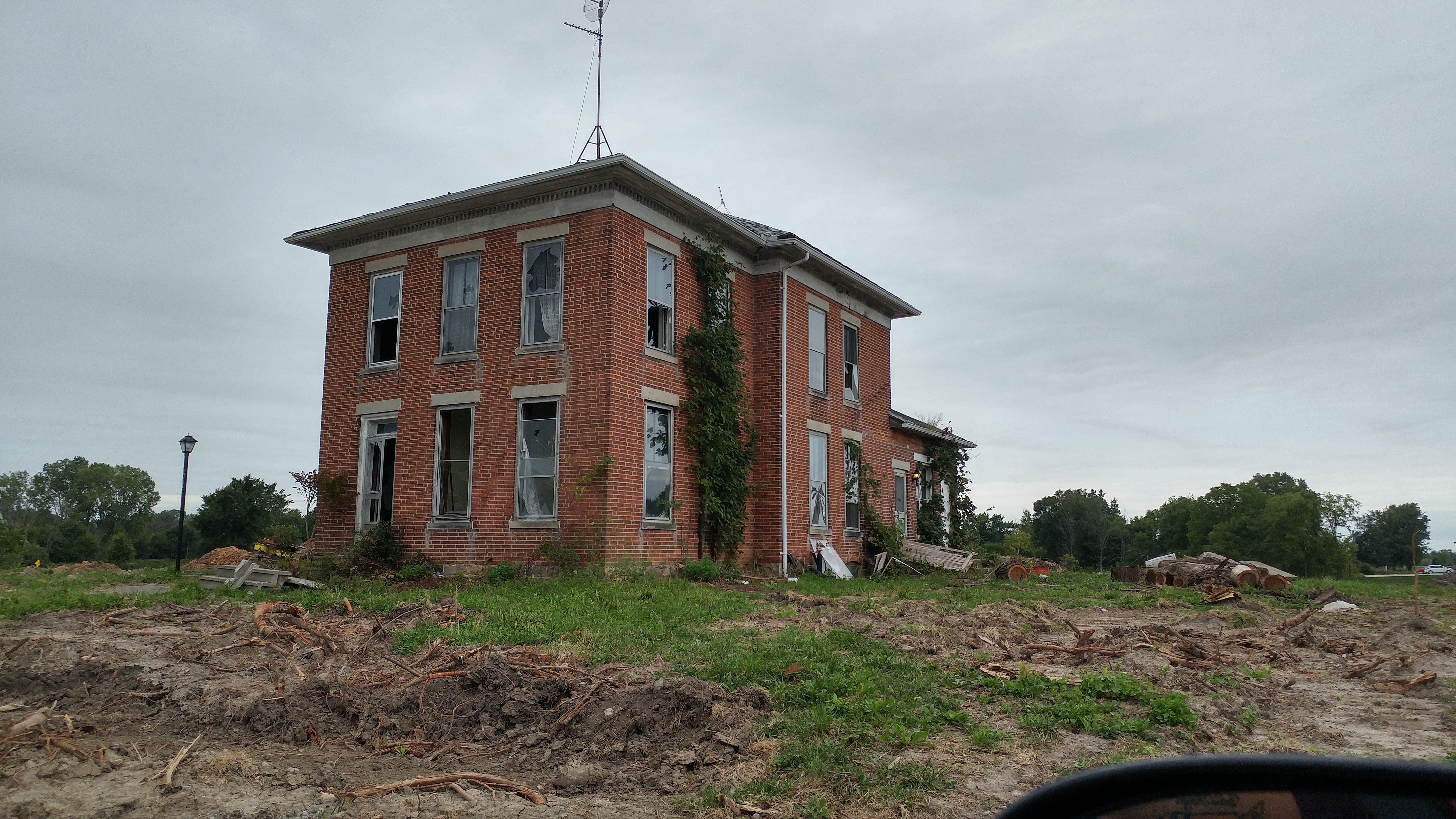
The farmhouse: No address found.  This building date of this aged, rough-looking old beauty is anyone’s guess.
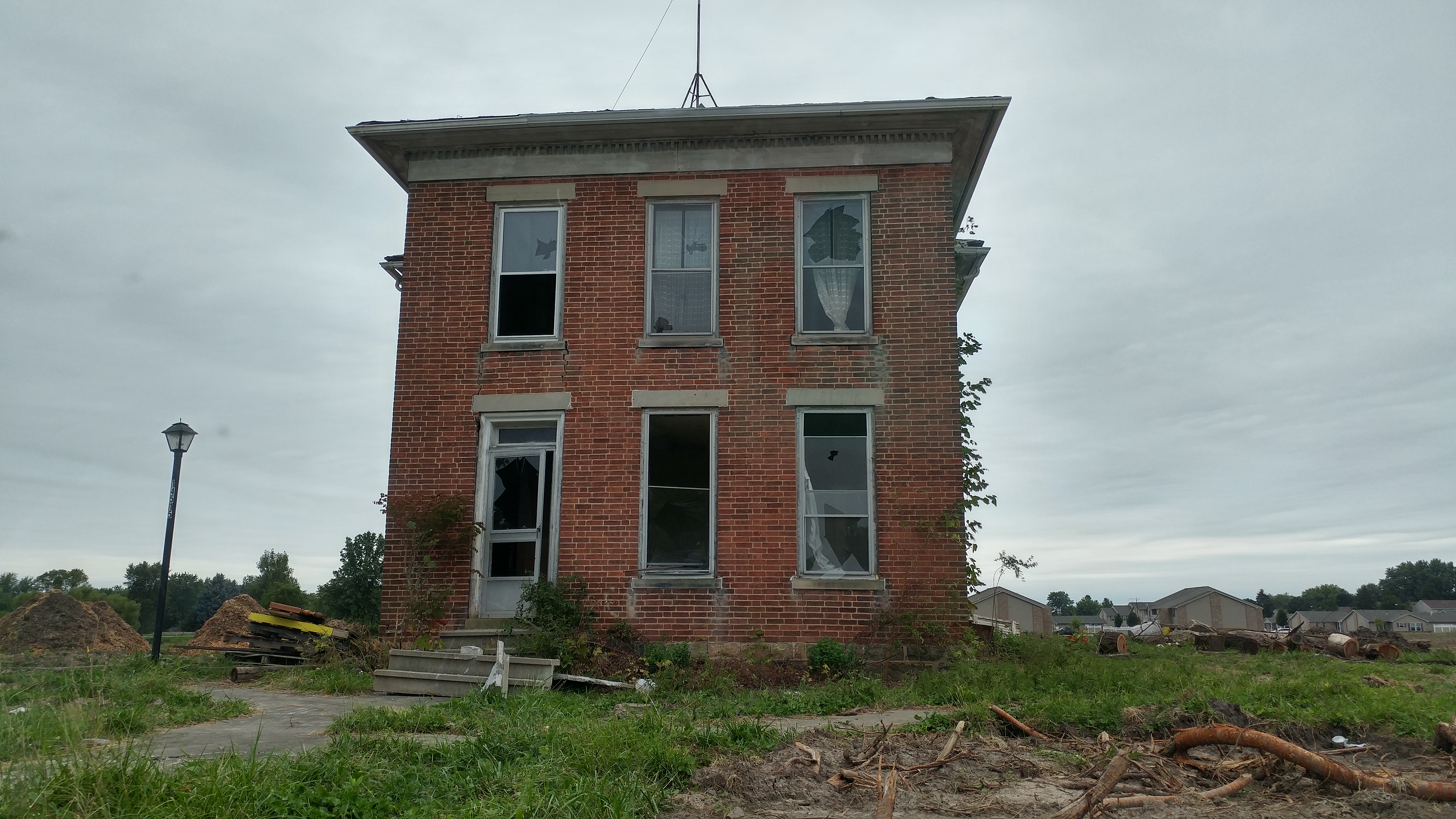
0907180855_HDR0907180854_HDR

THE SEARCH

Of course, I had to go find its owner–or at least try.  My first move was to google the street name.  That gave me the 14515 Echowood Lane street address.  While there were no photos, the listing indicated that the structure in reference was built in 1945.  I presumed correctly that the 14515 address applied to the white house given the obvious age of the brick farmhouse.

More googling brought me to this page, which happened to contain photos of the houses before the property was sold (and the structures apparently vandalized):
http://www.schraderauction.com/auctions/7075

BELOW: White house, approximately June of 2017 (according to the post date on the auction site).  According to the house number, this is actually 14510 Echowood Lane.

Ansons place intact 2

Below: The farmhouse, clearly maintained and cared-for slightly over 1 year ago.Ansons Place intact 1

 
Ansons Place intact 3

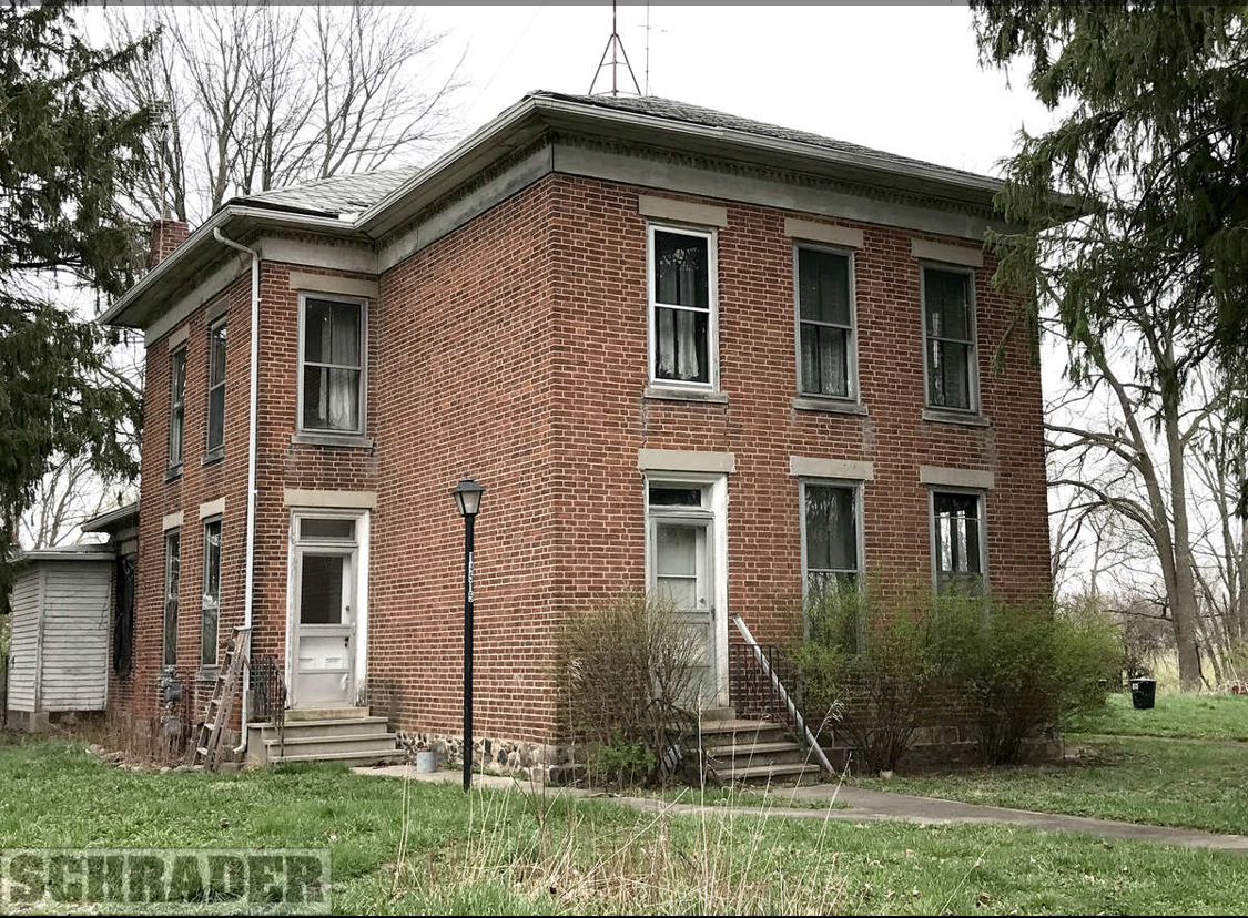
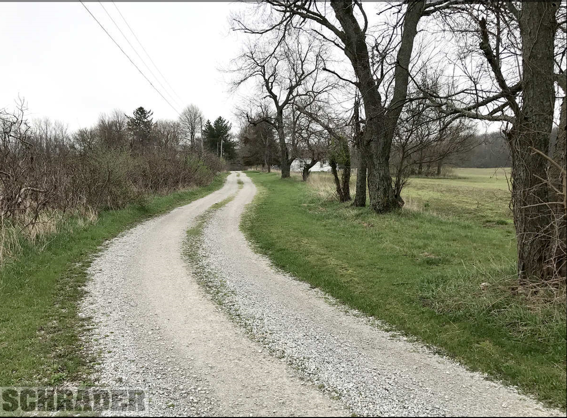
ABOVE: A sight never to be seen again–the drive down the pre-cleared Echowood Lane to the white house and the farmhouse beyond.

Details of a recently-held auction for the land upon which this farmhouse sits revealed that the brick farmhouse is a 4-bedroom, 2-bath home with a detached garage (not pictured).  It gives no building date.  However, one of the most valuable clues yielded by this page is the name of the owner of the property prior to auction: an LLC called Anson’s Place.

Unable to find more information on these curious buildings via Google, I headed over to Allen County’s Property Tax system.  There, I found the info I needed.
While the photo is of the white house on the property, the map on the right indicates that the area surveyed includes the entire property around Echowood Lane, and certainly encompasses the farmhouse.
Dunten Property Tax Info

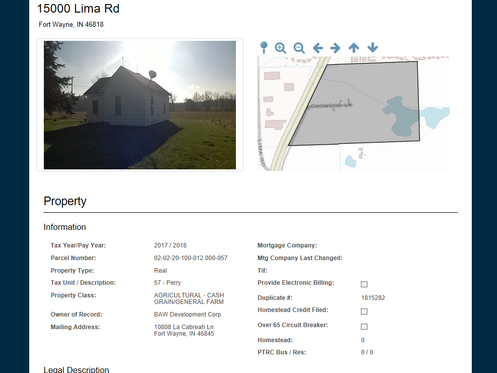
And in the listing of the transfers at the bottom of the page, I found what I was looking for: a name of the owners.  Vesta Ann Miller and Anson Dunten.  I was ready to head to Ancestry for a look at the census records.
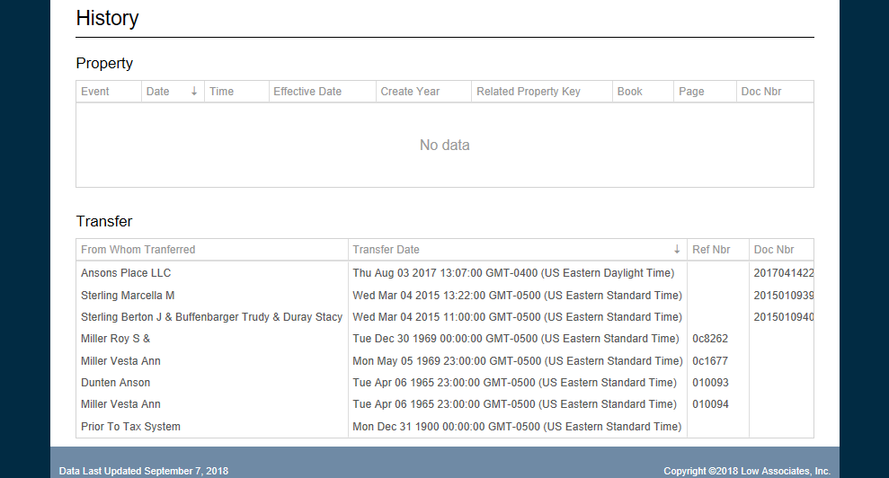
Dunten Property Tax Transfer Hx

THE FAMILY HISTORY

The fact that the LLC that sold the property was called Anson’s Place turned out to be a pivotal clue.  Anson Dunten (or in some places, Dunton) was almost certainly the original owner/builder of this property.  If not him, then perhaps Anton’s father.

Anson Dunten was born in Huntertown, IN, on May 18, 1856.  My goal was to track Anson through the census records and see if I could pinpoint an approximate timeframe as to when either he or perhaps his father built the brick farmhouse on Echowood Lane.

Now, as a side note, Huntertown is just to the west of Route 3, whereas this property is to the East of Route 3, meaning that by current definitions, this property is not technically in Huntertown.  However, things weren’t always quite that exact, the boundaries of towns change over time, and this property may in fact have been considered Huntertown at some point in its history.  It may also have been mistakenly presumed to be Huntertown by a census taker due to its proximity.  Just something to keep in mind.

1860: Anson Dunten is 4 years old, living at home with his parents, George and Anna Dunten.  They are listed as living in Perry Township, Allen County, which is the right township and county for them to be living in this house.  It is possible, just based on the minimal information in this census, that they are already living in the Echowood Farmhouse.  However…

1870:  Anson Dunten, 14 years old, is living in Perry Twp, Allen County with his parents.  He is working on the family farm.  So far, it is again possible that the family is living at the Echowood Farmhouse.  However, the census indicates at the top of the page that the post office for those censused is Eel River.  While nearby, Eel River Twp is a distinctly separate area, and chances are good that the Duntens are not yet residing at this iconic structure.

1880:  Anson Dunten, 24 years old, is still living with his parents.  He is now listed as living in Perry, Huntertown, Allen County.  It is possible, yet again, because the census is not as specific as it could be, that the Duntens have built and are living in the Echowood Farmhouse.  This is the only census in Anson’s life where he is listed as working as something other than a farmer (a schoolteacher).

1890: NO CENSUS

1896: May 26: Anson Dunten, age 40, marries Etta M. Harwood.

1897: May 9: Anson Dunten, age 40, and wife Etta, have a baby girl named Vesta Ann Dunten, who will be their only child.

1900:  Anson Dunten, age 44, is still living in Perry Twp, Allen County.  Interestingly, the word “Huntertown” is crossed out at the top of the page, having been written on the line “incorporated place”.  This certainly indicates that Anson isn’t far from Huntertown.  Even at 44 with a family of his own, Anson is still living in his parents’ home along with his wife, Etta, and his now 4-year-old daughter, Vesta.  All working men in the family are listed as farmers or farm hands.

By 1900, most of the families that are now considered the old farming families of the area have built their farmhouses and are well-established on their properties.  If the Duntens aren’t living in the Echowood Farmhouse by now (and they certainly could be!), they are nearby.  Neighbors with names such as Rodenbeck and Gump (the latter of which is the street name just north of the Echowood Farmhouse) are neighbors, meaning we are in the right vicinity.

1910:  Anson Dunten, age 53, is still living in Perry Twp.  He is, for the first time in a census record, listed as the head of the family, which would indicate that he either has his own place separate from the home his parents lived in OR he assumed ownership of his parents’ home.  He is living with his wife, daughter, and widowed father.  Of great significance (and what makes me think that this might be the first time we can safely assume the family is in the Echowood Farmhouse) is that Anson’s nextdoor neighbor is Henry Bleke, whose family owned several farms and land extremely close to the Echowood Farmhouse on the east side of Route 3.

1917: 2 Oct: Vesta Ann Dunten marries Roy S. Miller.

1920:  Anson Dunten, age 63, is living in Perry Twp, Allen Co, with his wife.  He is listed as a farmer still, but he is living on DuPont road, which is just a few miles south of the Echowood Farmhouse.  Now, given where he’s living, this would potentially indicate that the Echowood Farmhouse still hasn’t been built.  A few possibilities come to mind.
1.  Echowood Farmhouse is built, but it isn’t occupied by Anson (or perhaps, by anyone).  Also listed in the house is Anson’s nephew, Ralph Harwood.  Perhaps Anson and his wife moved to farm different land while assuming care of Anson’s nephew.
2. Echowood Farmhouse isn’t yet in existence.  This seems unlikely given Anson’s age.  He is currently 63.  While Anson does have siblings in the immediate area, it doesn’t come across as plausible that a man of his advanced age decided sometime between the ages of 53 and 63 to build a new house.  It is, however, still a possibility.
3.  Vesta (Dunten) Miller and husband, Roy, are living in the Echowood Farmhouse while her parents live on DuPont for whatever reason.  The 1920 census does show Vesta and Roy living in Perry Twp on a farm.  Roy is listed as a farmer, which is interesting because for the rest of his life, he give his occupation as a carpenter.  Neighbors include Hathaways, Tills (both street names in the area), Hillegas, Bleke, and George Dunten, Vesta’s uncle.  Perhaps Anson gave the house to his daughter when she married, and later, when she and Roy moved into town, Anson and Etta returned to the house.  Some variation of the above seems the most plausible explanation for why Anson and Etta suddenly aren’t on their farm in 1920.

1927: 1 Nov: Vesta Ann (Dunten) Miller and Roy Miller have baby girl Marcella Mae Miller.

1930:  Anson Dunten, age 73, and his wife are listed as living on Lima Road in Perry Twp, Allen County.  Based on the road name alone, this confirms almost beyond the shadow of a doubt that Anson is living in the Echowood Farmhouse.  He is still listed as a farmer.  Living nearby are a Bleke widow named Justine, a Salomon (another prominent farming family in the area), and the Rodenbeck family (also a common name in the area they’re living at the time).
Vesta and Roy Miller are living on Parnell Ave. in Fort Wayne in 1930 with 2-year-old daughter, Marcella.  Roy indicates he is a carpenter.

1935: Jan 26:  Anson Dunten dies at the age of 79 and is buried in the Old Huntertown Cemetery.

1940: Etta Dunten, widow of Anson Dunten, is censused living on Runnion Ave. in Fort Wayne with her daughter, Vesta Miller, son-in-law, Roy Miller, and granddaughter, Marcella.  Of note: Vesta, Roy and Marcella were all living in the same urban house in 1935.  Etta, however, indicates she was living on a farm in 1935 in Allen County, IN.  This jives with Anson’s date of death and tells us that she likely left the farm when Anson died.

1948: June 15:  Marcella Mae Miller marries Berton J. Sterling in Huntertown, IN.

Now, that answers the question of who Anson Dunten, Vesta Ann Miller, Roy Miller, Marcella Sterling, and Berton J. Sterling are.  We are seeing the property change hands through Anson’s living descendants, and a bit more snooping betrayed that Trudy Buffenbarger and Stacy Duray, listed under the March 2015 transfer just before Ansons Place LLC took over the property, are in fact the daughters of Marcella and Berton Sterling, making them Anson’s great-granddaughters.

As far as when the house was abandoned, according to the census records, the family of Anson Dunten ceased living in rural Perry Twp after Anson’s death in 1935 when his widow, Etta, moved in with her daughter and son-in-law.  All records for Vesta Ann, Marcella Mae and their families from 1940 on indicate that they live in town.  However, given the condition of the home in the 2017 photo, it is evident that someone has been at least maintaining the home over the past 80 years or so, and almost certainly living there.

It’s possible that the house was lived in off and on, or that the property was sold and eventually was bought back by the descendants of Anton Dunten.  It is even more probable that the farm was rented or only used for farming purposes by the family (not as a residence) since property tax records would indicate that it remained within the family at least from the 1960’s on.

Certainly, without a direct connection to the descendants of Anson Dunten, this old house, like many others, remains a mystery that will soon take its secrets back to the dust.