I can’t resist an abandoned house–that much, I promise you. But as much as I can’t resist an old derelict, I also can’t stand it when I cannot find the original history on a structure that promises a rich background, and that’s exactly what we have in this old house off Dixie.
I can tell you that this home appears to have been built in 1890 according to certain online resources (not verified). I can also tell you that the home was converted from a family dwelling into an office building for the B-T Energy Corp, an oil refinery, sometime in the 1970’s, abandoned in the 1990’s, and has been in a state of disrepair ever since. Twenty plus years of neglect–and likely, a bit of flooding and some less than-sturdy remodeling–have nearly finished the interior of the house, but despite it all, the brick exterior stands.
Take a walk with me again into another of yester-year’s mysteries, won’t you?

The scene upon walking up to this mysterious creature sitting quietly off US-31W just north of West Point. The area before the house looks like a parking lot, gravel and all. The overall structure of the house appears traditional to an older era–an L-shaped house, with the main house being the longer front portion and a smaller back portion coming off one side.

The house from the north side. Note the brick detailing over the door. My partner in exploration and I quickly determined this house dated back to the late 1800’s.

The photo above makes it clear that there was once a window of some size in the front center of the façade, as well as some sort of awning that has since fallen away, leaving only timbers jutting out over what would’ve been the old porch.

A full view of the house. Without the shrubbery of summer and spring, this house is suddenly starkly visible in white against the dreary brown of winter.

The remnants of the porch and evidence of the front door quickly prove that this entrance used to look much, much different.

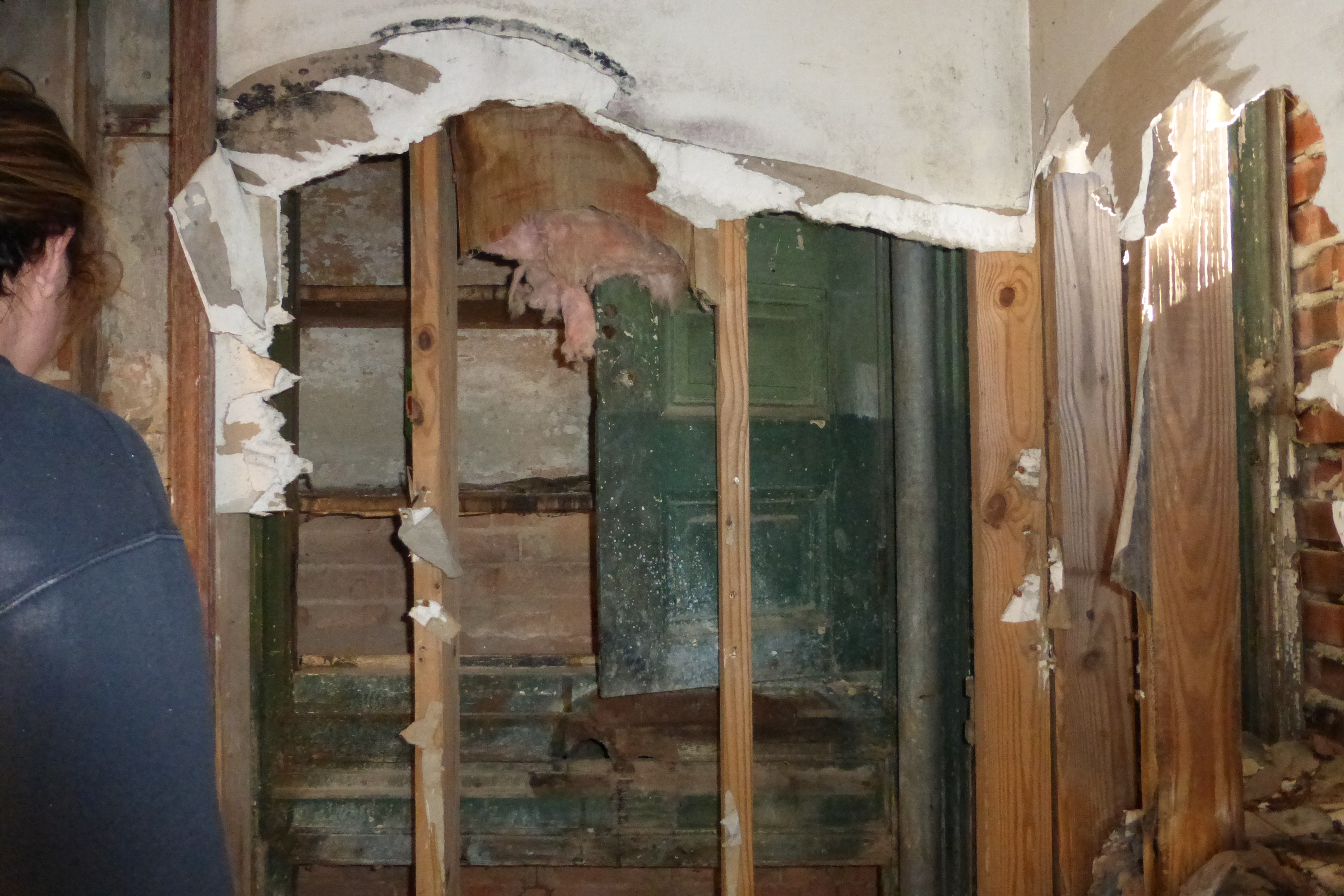
Looking directly into the house via the front door–a shocking surprise as it became quickly obvious that the home was in a severe state of disrepair. Note that straight back, a passageway under the steps appears to lead to a back portion of the house.

Peering to the left, a very messy room is obvious beyond the 1980’s-esque wood panel remodeling. Reminiscent of an office entry, this was the second clue to what had occupied the house before its abandonment.

A tenuous step inside and a look through the secretary’s window revealed a remodeling job that ultimately gave way to gravity and the elements as the second floor now rests in the first. At the back wall, an old fireplace is obvious in the upstairs as is the wooden structure of the false wall that sits like a frame inside the brick skeleton of the original dwelling. Slats for the original crossbeams are visible to the right.

Moving toward the section of the house that wasn’t falling in, we quickly found ourselves in a front parlor with a chair waiting to greet us. Again, the plaster wall stands a good 1-2 feet off the original brick of the house.

One of the resounding questions from this trip is in the photo above. Three initials in a heart etched deep into what appears to be the original wall beg the question: was this the work of creative vandals…or that of the original owners?

From the front right room, we walked straight back into the back left room. Here the remnants of the 1980’s remodeling are even more apparent. Based on the walls, this appears to be original–or at least added soon after the main house was built.
Closer inspection reveals more cabinetry behind the plaster, just like in the front right room. What was kept in this house that required so much storage?

Walking through the back right room and taking a hard left, we made a U-turn into this room, which appears to have been divided with paneling into two rooms. This room is suspicious as it has very wide windows.


Straight ahead, a doorway leads into the door that we had initially noted under the steps in the foyer. As this area would be located straight behind the staircase, it begs the question: was the second floor on this side of the back of the house original?
The picture below answers the question almost without a shadow of a doubt. We exited the house via the room above and took a picture of the room directly as we stood outside. The room we had exited is on the lower left of the photo below.

Looking at the back of the house, this is a clear view of the back of the L-shaped structure. Note the original brick to the right and the wide windows to the left on the first floor. The upper portion of the left section appears to be sided, suggesting that the second floor was added later. This would explain why the window on the back of the staircase in the foyer was bricked in had an addition over the porch become necessary.

This is the back view of the house from the south, the portion that appears original. It also appears that on the right and back portions of the house, the second story remains intact, but there is no safe way to access the second floor nor is there any guarantee that it’d be safe to walk through, so we settled on surmising and speculating as to what lay out of our sight.


View from the south, or the right side as I’ve been calling it. Note the awning that has fallen and is bowed precariously over the ground at the side of the structure. Also note several large holes on this side of the house. We can only guess as to what caused those.

That sums up our adventures with the house. We decided to wander a bit farther to check out the surrounding area. Amongst several foundations that we noted along the way, we also found a large oil tanker, two pipelines leading down to the river, and what appears to be a partially submerged pier on the shore.

This was the only tank remaining, but based on the concrete foundations for other tanks nearby, it was clear that the area was once filled with them.

One of the two oil pipelines that appeared to run from the area where the tanks sat to the river. This is the northern most line.

On the river, this is a photo of what appeared to be a partially submerged pier, or if nothing else, some vital piece of the oil pipeline that leads into the river. Wheels and valves of some sort are visible on both ends of this structure, which runs parallel to the shore, disappearing into the murky Salt River on the side facing away from the shore.

Above is the northern-most pipeline and the rest of the submerged pier structure.

Two pipelines running through the overgrowth down to the river.

If you have any information regarding the house featured in the earlier part of this blog, please comment below. I’d be very curious to hear from anyone with a reliable, valid source of information.
I will soon have the full album of photos from this adventure posted to Flickr. Stay tuned for the link!

This is the Steele House. It was a home before it was the petroleum company. The road down there is part of the original L&N Turnpike. I’ve been a few times in search of a cemetery and found it the last time I went with some people. If you’re looking at the house from the drive in, the cemetery is behind to the left, close to Dixie. It’s probably extremely overgrown so be careful if you go looking for it. I know someone who knows a lot more than I so if you’d like more info, let me know!
LikeLiked by 1 person
Thanks so much for the comment and the info! I’d be curious to hear more if you’ve got access to more information. This is such a majestic old place. It’s so sad to see it just fall down!
LikeLike
I used too work there when I was in high school. My dad managed the refinery and ran his tanker trucks out of there. I guess you could say I grew up there around that place. My dad started working there in 1965 when it was still Murphy oil Corp.
LikeLike
I seem to remember it looking a lot more “house” like in the 1980s when I was a kid- I suspect the 1997 flood did most of that damage. It swallowed up West Point – Dixie Highway down that far is on the wrong side of the floodwall, and was right in the middle of the river.
LikeLiked by 1 person
I love reading your explorations. I have been trying to find information out about this house as I have just started getting into abandoned properties and this one has been at the top of my list to try to explore. Are there any no trespassing signs posted? I would hate to go on the property only to be ran off or something.
LikeLike
Hi Shelly, thanks for reading!
I don’t recall seeing no trespassing signs, but I also recall not being surprised that there were none. That house is on the verge of collapse internally and it doesn’t appear that anyone really gives a rip.
If you do go to take a look and there are other explorers at this site, chances are good that you’d notice before you got too far. The most obvious way to the house is to park on the shoulder off Dixie Highway as there is a gate that prevents you from driving into what used to be the B-T Energy Company parking lot. As such, chances are that you’d notice other vehicles and/or other people pretty quickly–unless, of course, they took a different route in.
That said, exploration of abandoned places is inherently risky. Proceed with caution and have a backup plan of some sort just in case!
LikeLike
My dad grow up here and can tell you all about this place. If you tell me how he can contact you he would love to tell you all about it
LikeLike
He has home movies of this place as well
LikeLike
Hi Stacy,
Thanks for your post! Any information you or your dad could provide would be great! Please feel free to comment on this post or under my “about” page.
Thanks!
WW
LikeLike
I worked at this place when I was in high school. My dad ran the place in late 70’s and early 80’s
He ran his tanker trucks out of there hauling pipeline interface to the refinery. He started working there in 1965 when it was still Murphy oil Corp. It sure didn’t look then like it does now. It saddens me too see it like this. All the big tanks and other buildings are gone. Don’t know what happen to them.
LikeLike
I have wondered about this place for years, other than just being nosy, I love the history of places, so jst wanted to say thank you, cause my dad was wondering about this place also
LikeLike
This place was my mother and father’s first residence after Marriage back in1937. They rented the upstairs apartment from a man as I remember his last name was Osmiller (not sure of the spelling). My father was a soldier at fort Knox Ky. during that time (Aloysius R Jacobs). I believe that my mother (Zedith Jacobs) told us kids that they paid one dollar a month for their rent. My sister (Anita) was a child there and we have family pictures of them living at the old place. There were horses at that place, and I have a picture of my father at full gallop on one of them.
My Mom and dad have passed now 1988 (dad) and 1993 (mom) and just this year my sister Anita (2020). Several years back my wife and I stopped there and went through the old place and I found myself getting a lump in my Throat thinking about My Mother and Father as Newlyweds there. I tried to capture the feeling that they might of had there as newly weds compared to our first little apartment in Louisville and the love we shared there. Yes I am sure there are many stories there of those who have come and gone. Only the memories and crumbling debris remain today. But the memories left at least those of mine, are of individuals I dearly loved and still love yet today…May God Bless Their Memory!
A. Ray Jacobs
Ottawa, Illinois, 61350
LikeLike
i remember a large boat docked there when i was a kid. also…is the cemetery for the family members?
LikeLike